
New Gascony
Site Brief:
Founded: 1910
Location: Altheimer, AR
Additional name(s): None
Affiliate group(s):
Pine Bluff Historical Society
Arkansas Archeological Survey of UAPB
History:
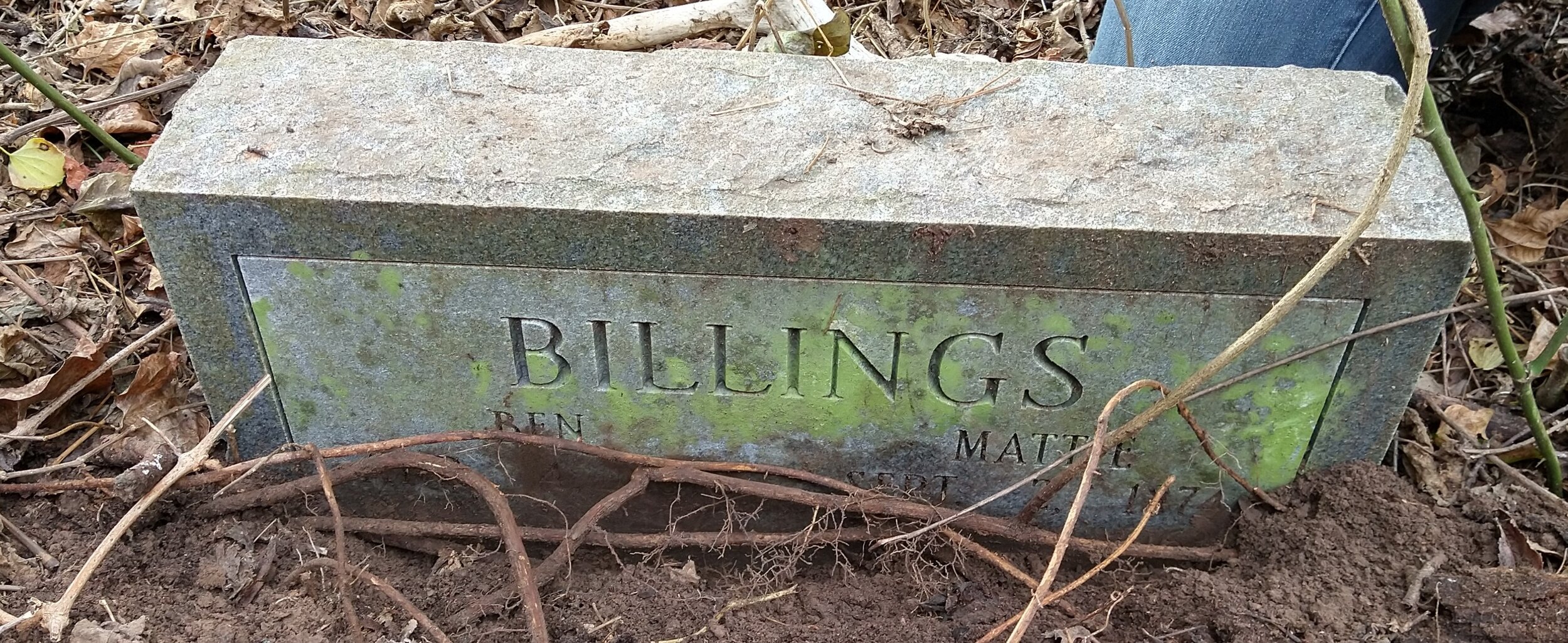
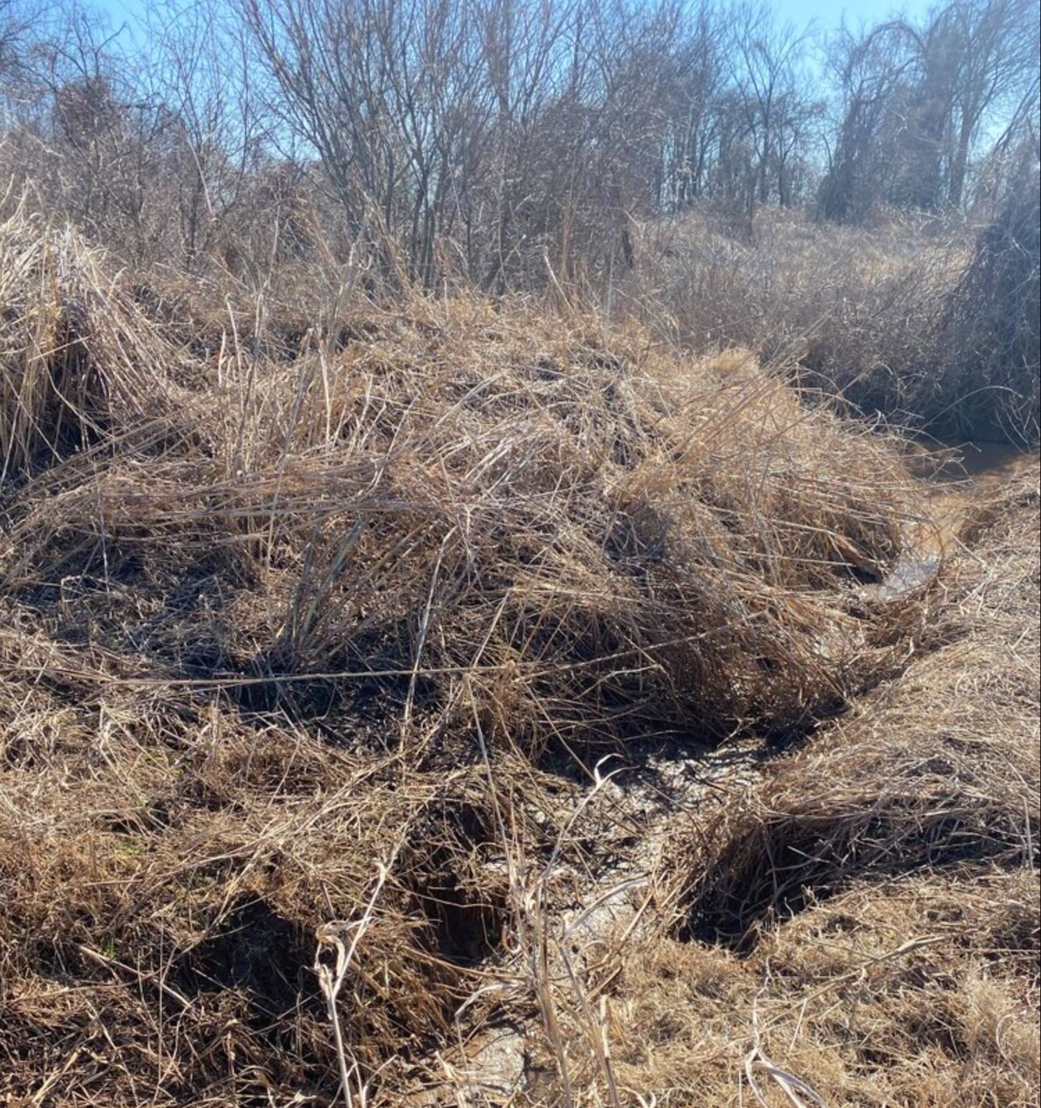
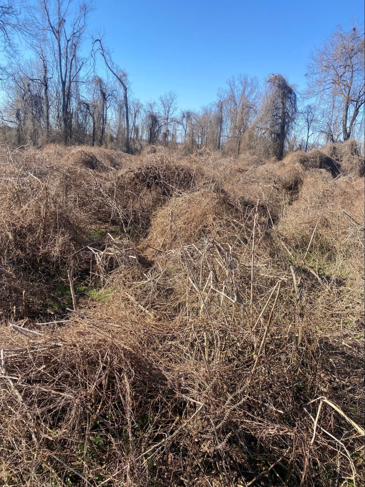
The cemetery does not appear on the 1905 map but does appear on the 1935 map. I do not know when it was established. The oldest burial found was 1915. The most recent burial was in 1972. The cemetery fell out of use soon after that as the community around it migrated away. Many moving north to Chicago. The stones found so far are very spread out, but mostly intact. There is very little damage to be found on each one so far. A few aluminum grave markers have been found, but no names or dates could be seen on them. There are plenty of grave depressions. There is even one grave enclosed with fencing, but I could not find a head stone for it. The cemetery is lined with tall trees and covered in vines. The cemetery is surrounded by row crop fields that vary between corn, soybean, and cotton. The area of the cemetery has been left to itself, unattended or molested.
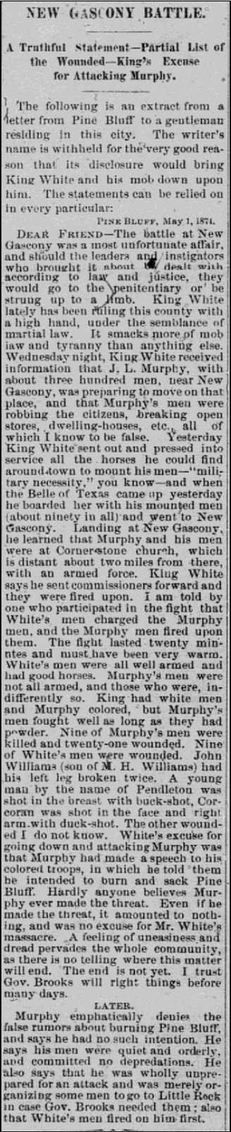
New Gascony was founded in the 1800’s by a Frenchman. He named the town for his home of Gascony, France. There was an attempt made to have it be made the county seat. It was the county seat for a short time before reverting back to Pine Bluff. New Gascony was a popular stop for boats going down the Arkansas River, having it’s own dock. The mail route came through here from an early time in the county. It was even included on most train schedules in the area. A Mr. John Gracie was a large land holder, owning most of New Gascony. At times the town is referred to as Gracie. This town included a few churches, school houses, saloon, post office, corner store, and a few cemeteries. Several homes lined the streets at some point too. During the time of Mr. Gracie several Italian immigrants came to the area to work on the land as tenant farmers. They established a catholic church and cemetery not far from the New Gascony Cemetery. The catholic cemetery was used for the white Catholics of the are, while the New Gascony Cemetery was for the blacks (often Baptist). I think there was a Baptist church across from the cemetery at one point, but I can’t be sure yet. The area produced many crops and families over the years. But with the strong ties to slavery, rasicm never left the area. Black farmers were pushed off their own land, through dubiously legal means. Pine Bluff was often a site for KKK meetings and marches. The black community lessened and lessened until they were pretty much gone. The land that use to hold homes turned over to fields and trees. Old houses were often burned down or striped down for parts. A few blank spots remain as a reminder of what use to be. Very few people know of the cemetery now. Or if they know of it, they know only that it exists.
Additional Information:
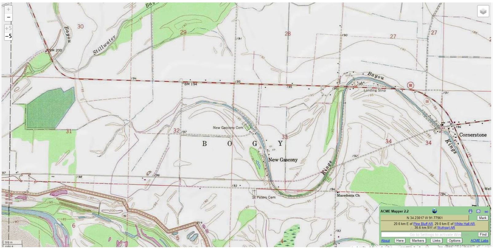
The New Gascony Cemetery is located in New Gascony, Bogy Township, Jefferson County, Arkansas, USA. The cemetery lies along King Bayou, on King Bayou Road. The road is dirt, and mostly used for farm equipment. New Gascony is very close to the river and has a levee named for it. This area was part of a very large plantation that used slaves and the prisoner labor after slavery ended. Most of these prisoners were black people who were very mistreated, often dying on site and buried without ceremony in New Gascony. I have come into contact with living descendants who would like to restore the cemetery and like my idea to commemorate these people.
Plans for Restoration
Overview: I’d like to convert this bedraggled space into a pollinator garden that can be visited by the family and the public at appropriate times. Jefferson County is known for being a farming community as well as part of the monarch butterfly migration.
Step 1: We’ll need to clear around the outer perimeter of the cemetery. This will give us a defined area, something to work inward from. The trail needs to be walkable for people to get though with tools. We will likely need to make a small bridge to get over the bayou. The bayou is wide and deep enough to be discouraging to get through, especially with tools in hand. The tools for this job would likely include a machete, rake, and weed eater. These tools would be the most helpful in establishing the perimeter. From the perimeter we can start making trails to the known headstones. There are at least 5 that have been found and listed so far. Each headstone has been mapped and can be found that way. So, from the perimeter we need to make a trail to each stone. Then from each stone we can make our way through the inner part of the cemetery to connect them. It’ll look something like a maze a first. The tools mentioned earlier will be good for this too. We’ll need an area where we can start to burn the foliage we pull out. Some plants can be tamped down, but others will have to be removed and dealt with. Burning is the most efficient manner and will cost us less to remove that way. We’ll need permission from the landowner and ground rules for burning so we don’t hurt the crops around us. We may have to wait for late fall or winter. Once these things are established, we can move on to step 2.
Step 2: Moving out from the known headstones we will need to gradually clear more space. This will be needed to find more stones as well as just clear the area. We can choose one headstone and work in a fan shape from there. All headstones found must be documented. This included pictures, rubbings, mapping, and a numbered flag. The flag will assist in getting the cemetery properly mapped later on.
Step 3: Once more area is cleared, we can use more tools to find buried headstones. These tools include long steel bars to poke into the ground. We may also be able to get NCRS involved with ground radar. They may be able to find buried stones or remains of casket hardware. After this is completed, we can start mapping the cemetery with Archaeology.
Step 4: Planting the pollinator garden is one of the final steps. Seeds and plants will need to be native species that will thrive in the environment of the cemetery. Trails to the headstones should be kept clear. The plants can fill in the abundant space around the known burials. We’ll work with UAPB on these recommendations. We’ll also arrange for bee hives to be placed nearby as part of UAPBs ongoing extension and research. A sign will be constructed at highway 88 to indicate the location of the cemetery. A ribbon cutting ceremony with relatives of the interred should be arranged.